|
Unless you enter the park before 7am or after 5:30pm, with few exceptions
(such as, you're camping there), you can't drive into
the Devils Postpile National Monument. Instead, you must take a shuttle
bus from the Mammoth Mountain ski area. This prevents cars from clogging
the narrow winding road down into the valley.
We got another late start, arriving at the ski area a bit after noon.
The shuttle is basically like a school bus. In fact, our driver was an
old school bus driver. The bus was about half full. After peaking
at the park entrance, the trip is all downhill, about 1500 feet down.
Along the way are great views of Minaret Falls and the surrounding
mountains.
The bus has 10 stops. We took it to stop number 6, Devils Postpile.
The night before I had thought about two options: (1) hike past Devils
Postpile to Rainbow Falls, and back -- a 5 mile round trip; or (2) hike
to Devils Postpile and back, about a 1 mile round trip, take the shuttle
to the Rainbow Falls trailhead, then hike to Rainbow Falls and back (about
1.5 miles round trip). While on the shuttle I realized there was a much
simpler option that wasn't mentioned in any of my hiking books. We would
hike past Devils Postpile to Rainbow Falls, then hike back to
the Rainbow Falls Trailhead. We'd take advantage of the shuttle, which
we were required to use anyway. If you are planning a trip here, you can
use the shuttles creatively to do longer hikes than you normally could
without a shuttle, and without the hassle of having to arrange a car
shuttle.
There's a small visitor's center, where we picked up a small map and
refilled on water. It was quite a warm day, although our return bus
driver said that it was about as hot as it gets (in the 80's). After
putting Nathan in the baby carrier, we started off on the sandy, level
trail. The trail roughly follows the San Joaquin River to the right,
past typical Sierra forest.
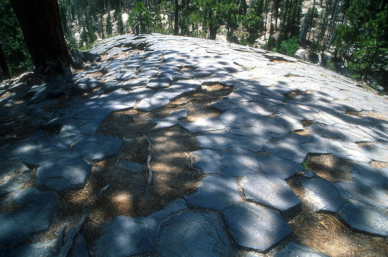
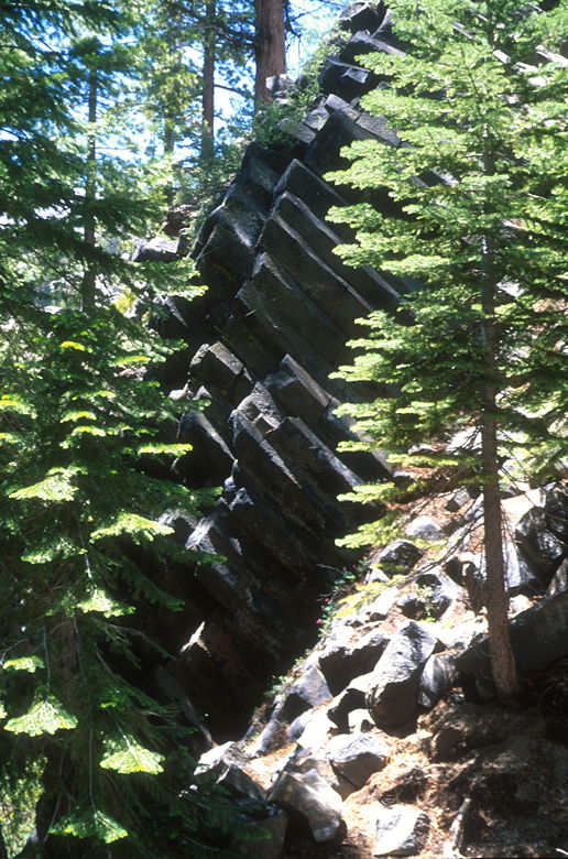
Top of the Devils Postpile
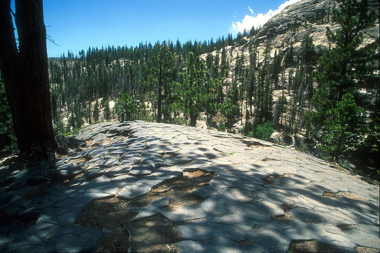
Top of the Devils Postpile
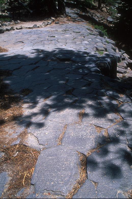
After just 0.4 miles, we reached the Devils Postpile itself. Here's
where I made my mistake. I could see some of the columnar basalt rising
up in front of us. Instead of staying on the main trail, I decided we
would head up to the top of the postpile, then double back a bit to see
it from ground level. As it turned out, we never would.
Top of the Devils Postpile
Top of the Devils Postpile
The trail up to the top of the postpile is steep, but relatively short.
Still, it will have you huffing and puffing by the time you reach the
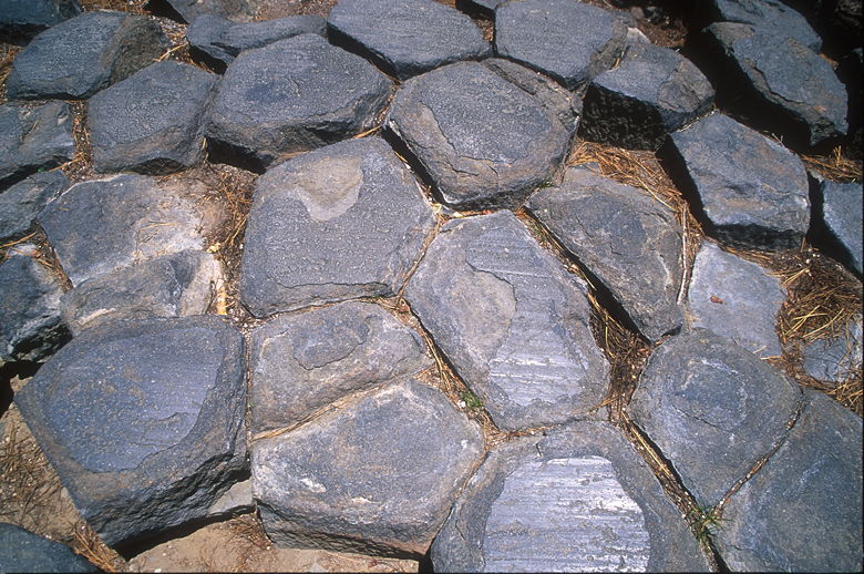
top. Here you will see what look like unnatural hexagonal tiles on the
ground below you. After marveling at them, we continued on up the trail,
which winds its way up a bit more, then steadily back down. There are a
few other signs of columnar basalt, but nothing spectacular. The best
display on this part of trail is near the bottom, where you can see a wall
of diagonal columns (diagonal into the hillside, not across it).
Basalt columns
When we reached the intersection with the main trail, I decided I didn't want
to torture Jean anymore, so we turned left instead of right, which would have
given us a chance to see the main display of columnar basalt. We'll just
have to return another time.
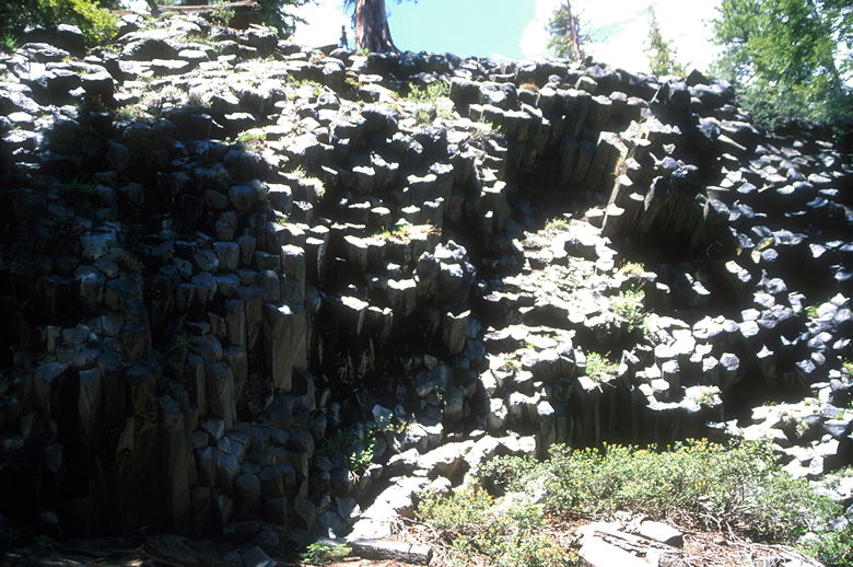
Many more columns
The trail still roughly follows the San Joaquin River,
following it downstream. The trail is typical Sierra forest until it turns
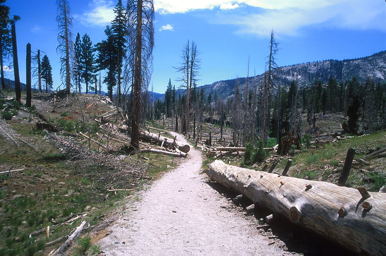
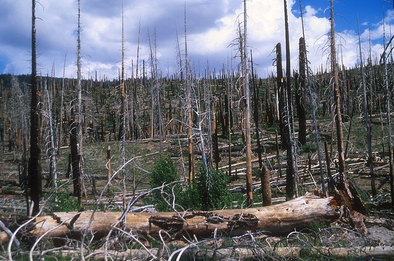
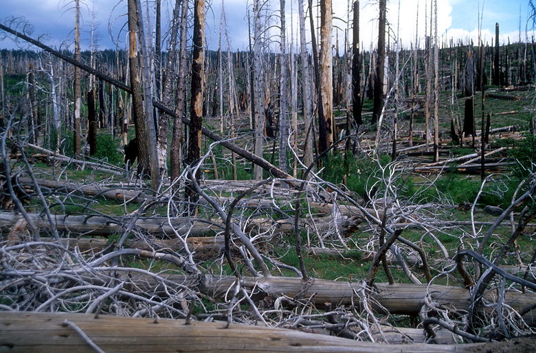
a corner and dumps you out into a surreal scene. A 1992 forest fire, dubbed
the "Rainbow Fire", swept through the area. What's left is scattered
surviving trees, a lot of burnt empty shells, and the beginnings of new
life -- little trees no more than 4 or 5 feet tall. I had hiked through
fire-damaged areas before, but nothing so large and devastating. It
didn't feel like a real hike anymore. It reminded me of hiking in Bryce
Canyon, where you feel like you're walking in a museum. It seemed eerily
quiet.
Entering the burnt forest
More of the burnt forest
We trudged along the sandy trail until we turned right, descended some
steps, and came to the first viewpoint of Rainbow Falls. The falls were
impressive simply in terms of the power of the water falling 101 feet.
As advertised, there was a rainbow at the bottom. At this time, the rainbow
was only visible from the first and second view points, but not the bottom.
A tree mars the view from the second view point, so if you don't have the
energy to go down (and, inevitably, up) any more, you aren't missing much.
But we didn't know that at the time. So we kept going down. At the top
of the steep steps leading down to the base of the falls, we talked to
some people coming up. We asked them if there was a place to sit down to
have lunch. They said yes, and we didn't press them on it. Unfortunately,
it wasn't until we reached the bottom that we realized that there were
places to eat, but no place for a 9-month old baby to crawl around safely.
So we enjoyed the mist briefly before heading back up the steep steps.
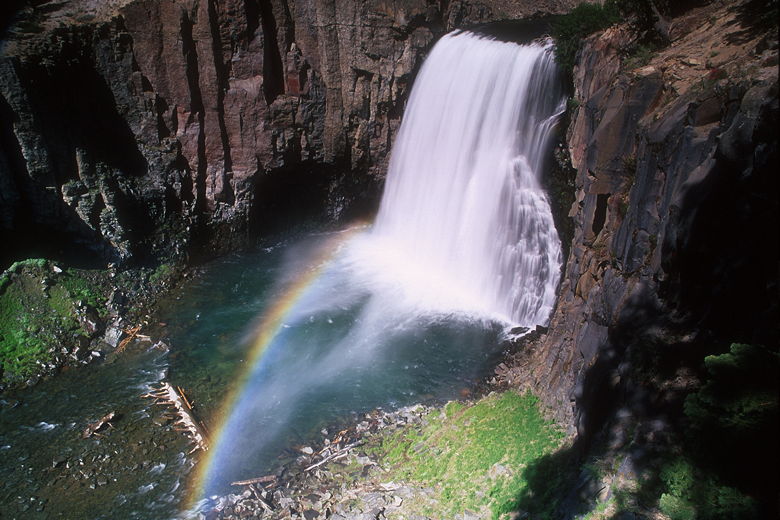
Rainbow Falls
We settled under a tree near the second view point to have lunch. While
we were there, a group of a dozen or so on horses came down. After lunch,
I headed up to the first view point to take some photographs. I wasn't the
only one -- a couple was already there, taking pictures with their digital
cameras. The man next to me complained that he couldn't get a long exposure
because his Nikon digital SLR only supported speeds of 200 - 3200. I
didn't have the same problem, since I was shooting 50 speed film. Chalk
one up for film. Still, I wasn't getting speeds as slow as I wanted, so I
used my graduated neutral density filter a little creatively, angling it
diagonally so as to darken the falls appropriately.
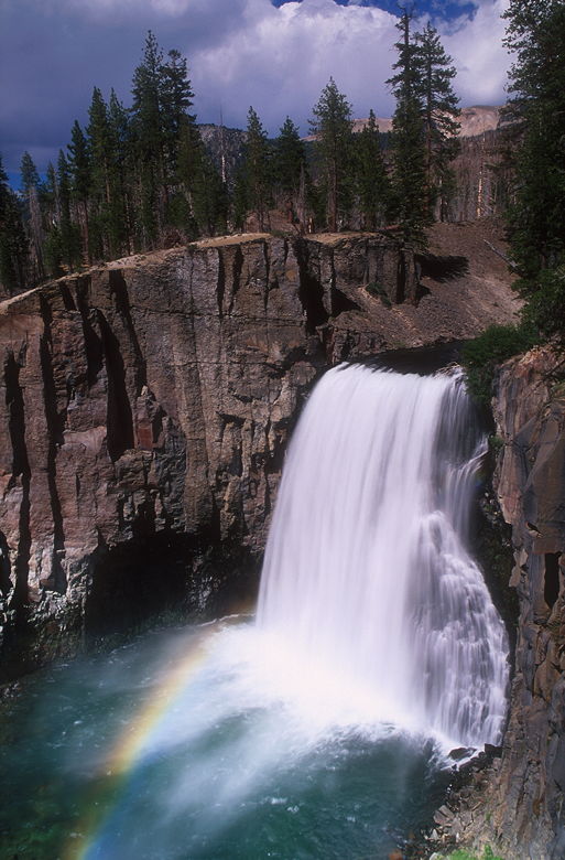
Rainbow Falls
As we were packing up to head back on the trail, the skies began to darken
quickly. Clouds had snuck up on us from the north, and I knew the
threat of thunderstorms was headed our way. We quickly finished packing
and headed back onto the trail. Passing through the burned-out forest
again, we took the right fork which would take us to the Rainbow Falls
trailhead. As we walked slightly uphill, we could hear distant thunder.
Fortunately for us, it never got close.
Back into the burnt forest
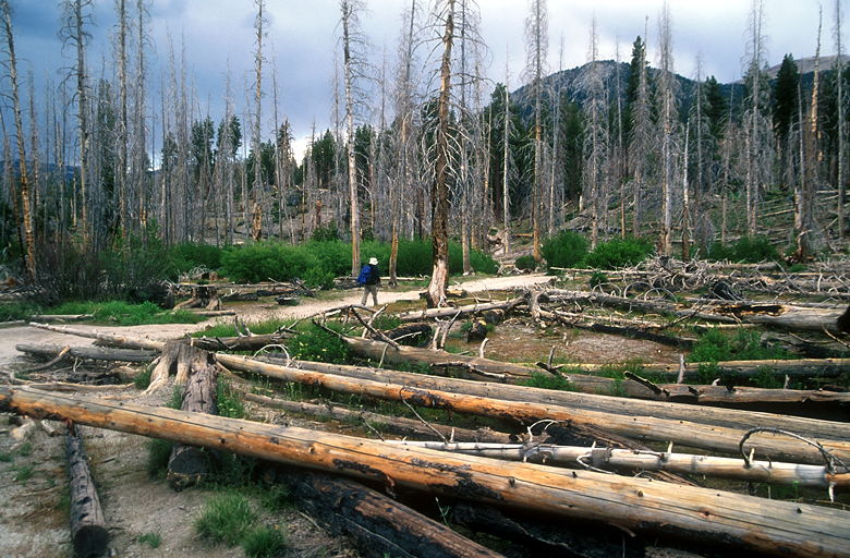
Jean in the burnt forest
Shortly, we reached the Rainbow Falls trailhead. The bus doesn't stop
there, though. For that, you'll have to walk a little more, up the main
road where there is a clearly marked bus stop sign. We just missed the
bus headed uphill, but I knew it would return shortly, as we were at the
second-to-last stop, stop 9 of 10. Soon the bus returned and we got on
for the trip back up. The bus would be completely full, and the driver
said that by July 1st, there would be 10 busses running, always packed.
|


