|
Ivan, Jean, Joe, Kelly, Lan, Reza, Sam, and I went to Mt. Tamalpais
State Park to hike up down to the beach and back up to Mt. Tam.
Eight months after I originally scheduled the hike, we finally did
it.
The plan was to meet at Pantoll at 1pm and start hiking shortly
thereafter. Unfortunately, seemingly everyone in the Bay Area was
headed toward Stinson Beach in the midst of a heat wave, and traffic
was horrible. By the time we reached Pantoll, the lot was full, and
some of us had to park a half mile up the road. We ended up not
starting the hike until about 2:50pm.
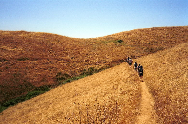
Rolling hills near the beginning of our hike along the
Matt Davis Trail
The Matt Davis Trail starts just across the road from the Pantoll
parking lot. The trail shortly enters a wooded area where the shade
protected us from the harsh sun which baked the area to 97 degrees.
After pausing at the edge of the shade, we continued along the trail,
out into the open, rolling hills with views of the shimmering ocean.
After about a mile, we re-entered the cooler forest and continued our
descent. Parts of the trail are very narrow, with brush touching us
on both sides. But the trail is generally well-maintained, with
wooden railings in some sections. We made a brief stop at Table Rock,
where we had great views of Stinson Beach below. Shortly thereafter,
we came across an unmarked fork in the road. We guessed correctly and
took the left fork. At the next unmarked fork, we took the obvious
right fork and a few hundred yards emerged from the forest onto a
road which led us past a fire house.
As we walked south along the Shoreline Highway, we saw a seemingly
endless line of cars extending along the highway, headed to the
beach. I thought that the hike would land us at the sands of Stinson
Beach itself, but we were still some distance from the beach when we
turned up the Panoramic Highway to the Dipsea Trailhead. I would have
gone down to the beach, but because we'd started late, I was worried
we wouldn't have time to make it to the top before sunset. In fact, I
was worried even without going to the beach.
It'd taken us 4 miles and 1 hour, 50 minutes to get to Stinson. We
had 3 miles to go back up to Pantoll, and then another 4 miles after
that to get to the East Peak. Shortly after heading up the Dipsea
trail, we stopped briefly to eat. At this point, Lan, Sam, and Joe
decided to stay back and take their time -- they'd stop at Pantoll
and drive to the top while Ivan, Jean, Reza, and I would continue
hiking to the top. After eating, we emerged again from the shade into
open, rolling hills. Then it was back into the forest, where we would
stay all the way up to Pantoll. After 1.2 miles from Stinson, we
reached the Steep Ravine Trail.
This is probably the nicest part of the hike. The Steep Ravine
Trail heads up the hills beside Webb Creek. The shade kept the
temperature to a bearable 80 degrees. There was lush green
undergrowth (plenty of food for Lan!). Unfortunately, Jean was
affected by the heat already, and we slowed partway up the trail. The
rest of the group caught up to us, and Ivan, Reza, and I continued
on. Time was becoming a factor, and Ivan literally started running up
the trail (he was probably just trying to catch the woman who'd
passed us). Reza and I tried to keep pace. So, while the rest of the
group enjoyed a nice pool where they stopped and waded, I don't even
remember noticing the pool.
We made it back to Pantoll about 1 hour, 30 minutes after leaving
Stinson. That left us a little under 2 1/2 hours to hike the
remaining 4 miles to the top. Kelly joined us at this point, but
Ivan, suffering from muscle cramps, stayed behind. The Old Mine Trail
starts along a paved road next to the Panoramic Highway, across from
the ranger station. It climbs up to the Mountain Theater -- an
impressive-looking outdoor amphitheater set in the middle of the
park. At the far right of the theater we found the next trailhead,
the Rock Spring Trail toward West Point Inn (do not go to Rock Spring
itself!).
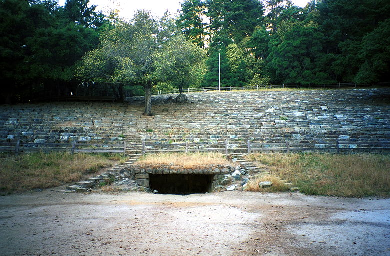
The Mountain Theater. Reza and Kelly refused to be in the
picture!
Along the Rock Spring Trail, the area darkened considerably and we
quickened our pace to avoid missing the sun set. Kelly, being fresh,
took me too literally when I said to pick up the pace -- she started
running along the trail. When we emerged from the trees, we were
greeted with gorgeous views of San Francisco, the bay, and the ocean.
We soon found ourselves at the West Point Inn (one of the few
structures you'll see along the trail, save a water tower). At this
point, we had less than 2 miles to go, and it was about 7pm, so we
relaxed as we realized we had plenty of time. We followed the Old
Railroad Grade -- a fire road where we saw a few mountain bikers and
some hikers. We ended up on the road just below the back of the East
Peak parking lot, and found the rest of the group at the top,
relaxing.
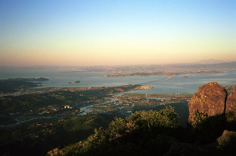
Richmond-San Rafael Bridge from East Peak
We did, as a group, the short hike up to the East Peak. There we
took in the views of the entire area as we relaxed and waited for the
sun to set. Several other people scattered themselves around the area
as they waited, as well. To the east, we could see the Richmond-San
Rafael Bridge, Mt. Diablo, and the East Bay. To the south, the Bay
Bridge. To the north, rolling hills and Bon Tempe Lake. To the west,
the sun setting into the fog and ocean.
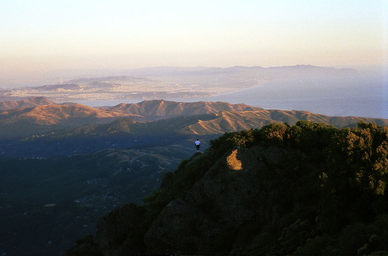
Sitting on the edge of nowhere. That's San Francisco
through the haze.
Because of the heat, the fog was slow to creep in. Thick fog
surrounding the area is what is supposed to make the sun sets here so
amazing, since the peak is above the fog line. Unfortunately, that
was not the case for us, but it was still nice to see the sun set.
The sun seemed to hang on forever, though. It sank to the horizon,
which started to glow, and then slowly faded. It seemed to just sit
in the fog, like an iceberg, a small portion of it visible above the
fog for seemingly 10 minutes or more, before it finally sank
completely.
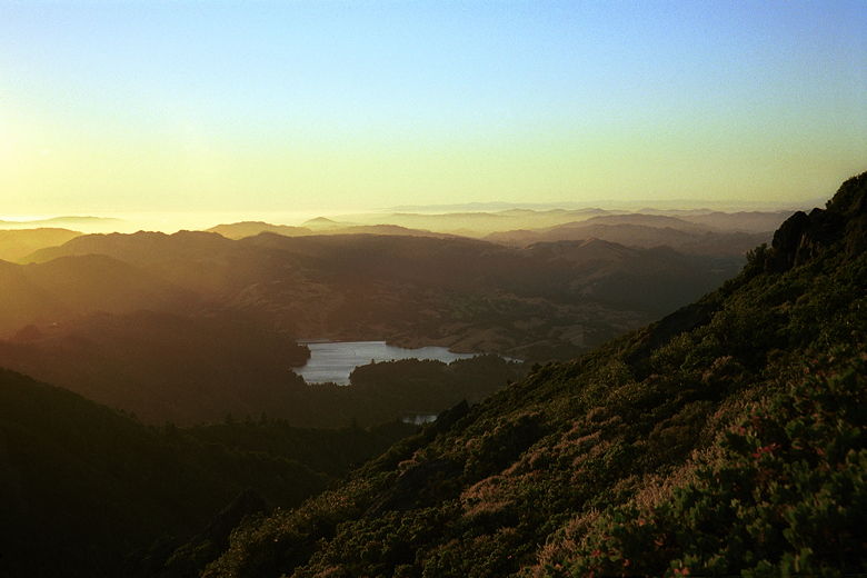
Last rays of light hitting Bon Tempe Lake
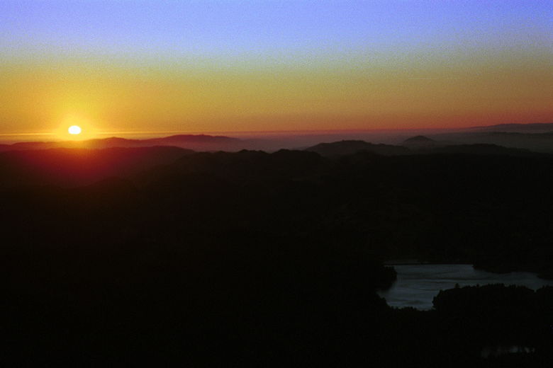
Sunset from East Peak
Afterwards we made our way down in the dimming light. I'm
disappointed in myself for failing to remember to bring a flashlight,
but it was bright enough that we didn't need it. Then it was back in
our cars and back down the winding road to civilization.
|


