|
Unlike two days ago, when I hiked to Asa Lake, the parking lot was filled
with cars -- about 10 of them. Knowing it was a long hike and a hot day,
I took along
a gallon of water and Gatorade. I thought about taking more, but my pack
was already pretty big. I'd regret this decision later...
I started off on the trail around 9:10am. The first 0.6 miles is the same
as the hike to Asa Lake. This time, instead of taking the fork to the left,
I took the fork to the right. The trail descends briefly, then is mostly
flat as it goes through Upper Gardner Meadow for about a mile. It is quite
pretty here, especially in the morning light. It's a very large meadow,
with lots of mules ears.
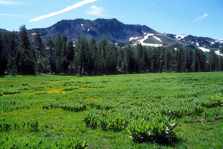
Upper Gardner Meadow
As I approached the next trail intersection, I noticed a fisherman coming
up behind me. I took the left fork toward Disaster Creek, and he took
the right fork (straight ahead) to Arnot Creek. The trail climbs briefly,
then descends into the forest, skirting meadows here and there. It was
quite muddy at times, but nothing where I sank in.
After skirting another muddy meadow, the trail veers to the left into a small section
of forest. I lost the trail at this point. While I was wandering about trying
to find it, two day hikers came barreling through. They were carrying next
to nothing (maybe one or two water bottles). Not sure where they were headed,
but at least they did find the trail, on the other side of some more muddy
meadow to the right of the trail I was standing on.
The trail shortly disappears again, but after crossing the creek, you'll
find it on the other side, heading south, parallel to the creek.
After less than 10 more minutes of walking, I crossed a small creek. The
Schaffer book says that after 0.6 miles from where I'd just been, I'd
cross a creek and then start going cross-country to the left. But it was
too soon for that, I thought...I couldn't cover that much distance that
quickly. So I thought maybe it was the wrong creek...there were so many
seasonal run-offs from the snow melt, who knew? So I kept going.
I kept looking to my left, trying to see evidence of cross-country activity,
but I couldn't find any. At one point I stopped near some old fences and
took the book out. While I was there, the mosquitoes converged on me. I
quickly decided the book wasn't helping and I kept going. I was about to
turn around and head back up when I saw three backpackers coming up toward me.
I asked them how long it'd been since they were at the Disaster
Creek/Paradise Valley intersection. They said it'd been about 30 minutes.
Given that it was 2.1 miles from there to where I wanted to go, I was
close to a mile too far down the trail!
I decided to stop here and eat something before heading back up the trail.
My altimeter said 8200 feet, and the map said I wanted to cut across
at about 8390. Part of me wondered whether I should just call it a day,
but I still had plenty of daylight left, so I continued. I headed back
up the trail, continually scanning for cross-country activity (i.e.,
footprints). I didn't find any. Eventually, when my altimeter said 8350,
I decided to just go for it. I just took out my compass and started
heading northeast.
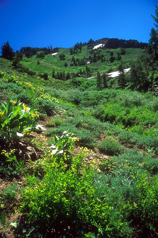
Climbing through the brush
After quickly exiting the forest, I encountered mostly brushy terrain.
Low brush, about mid-calf high. I was glad to be wearing long pants
(a must for off-trail travel). I shortly encountered cow pies on the ground,
which was actually a comforting sight. If cows came here, maybe people
did, too? I couldn't be that far off. I climbed up a steep gully, trying
my hardest to get out. As I got higher, I saw more wildflowers, too
numerous to identify. Of course that also meant I started sneezing.
Climbing the steep slope
I tried my hardest not to trample the flowers as I switchbacked my way up
slowly. A creek flowed to my right as I veered to the left to exit the
gully. Eventually I reached a plateau where I rested and evaluated the
terrain ahead of me. I also stopped to take some pictures of the most
striking flowers here, pink ones with yellow tinges on the edges.
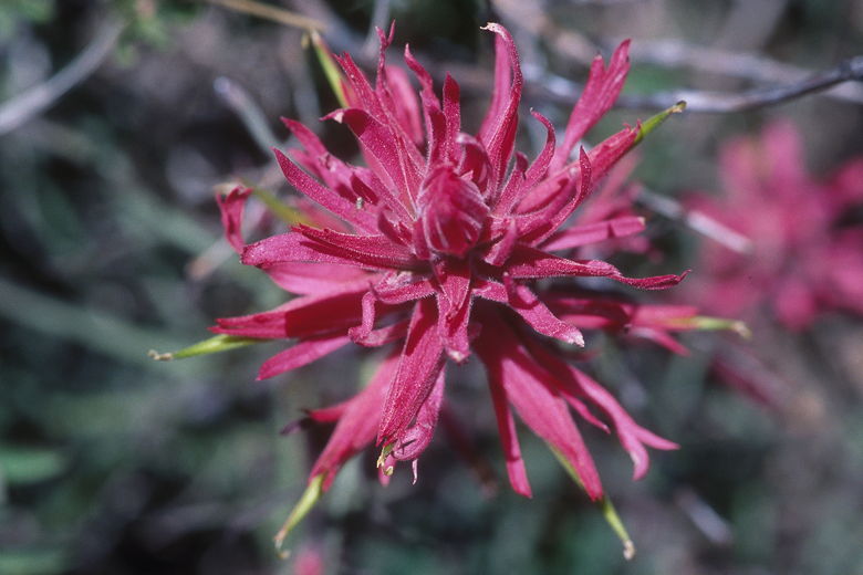
Flower
Above me was a large snow bank in a gully. I had to decide whether to go
left or right of the snow bank, which was much too steep to walk on itself.
The left side had less vegetation, so I decided it would be easier than going
to the right, which looked initially steeper. Looks can be deceiving, however.
It turns out I made a horrific mistake.
The path I took had less vegetation for a reason. It was steeper and probably
prone to avalanches in the summer. While there was no snow directly above
me, it was still very steep, and got steeper and steeper as I got higher.
The higher I got, the slower I traveled. Since I was hiking solo,
I had to continually think very carefully about what I was doing.
Especially since I was now off-trail. If I broke an ankle or was knocked
unconscious for whatever reason, help would be far off (or too late) in
coming. I understand the risks of solo hiking and I hope you (the reader)
do as well. It just happened that I wasn't able to find a hiking partner
for this hike. That being said, I don't recommend this trip solo for
anyone who doesn't understand those risks. People fall and injure themselves
all the time. If you're alone, the situation is magnified.
Okay, I admit, I fell. Once. Luckily for me, I only slid down about a foot.
There was also a tree below me, although it's debatable whether it would
have stopped my fall. The rocks I knocked didn't stop after a foot, though.
They kept falling and falling, maybe 100 feet down. After that I was
extremely careful with each and every step. I could see the promised
land of solid ground just a few feet away from me. Turning back at this
point wouldn't have been any safer, so I made those few steps until I
breathed a sigh of relief and walked on solid ground.
The rest of the way was easy compared to what I'd just been through. I made
my way past the wildflowers and bushes, up to a broad saddle. Contrary
to what the Schaffer map says, the saddle is definitely not at 10,040 feet.
It's more like 9650 feet. It's a huge saddle, about the size of a football
field. It's quite windy at the top. After stopping to rest a minute,
I turned right to head up to the summit. Following the book's instructions,
I veered to the right to avoid tackling a slope head-on. As I did so,
I found an old knife lying on the ground, still in its case. I left it there.
I made the final push to the 10,054 foot summit, past some brightly colored
Indian paintbrush. There are two metal boxes at the top. One of them
contains the summit register. The other contained newspaper clippings
and photographs. I'm not sure what it was -- maybe a memorial of some kind?
It looked like I entered the third entry in the summit register this year.
There was one from June 22nd, and another from this morning. I'm guessing
that most of the entries come between July and October. I guess I must
have just missed the two backpackers with their two dogs. It was 1:15pm
when I summitted. I wrote my entry and then enjoyed the views.
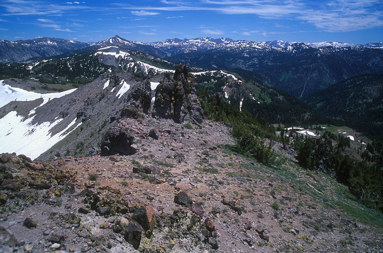
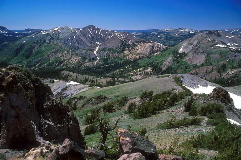
View from the summit
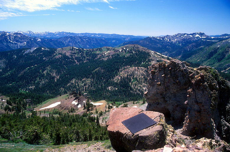
Plaque on the summit
The views from the top of Arnot Peak are amazing. You feel like you're on top
of the world. They're much better than the views from Hiram or Folger.
Part of that might be because both of those peaks are so close to the
Highland Lakes campground just below. Arnot Peak, on the other hand, feels
like it's far away from everything, especially after the cross-country
travel. Mountain views stretch off in all directions. There were
snow-capped peaks to the south. At this point in the year, probably only
11,000 foot peaks would be capped with snow.
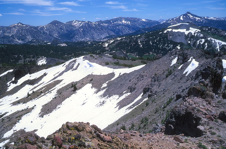
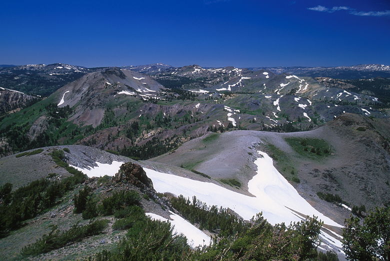
Snow slopes below Arnot Peak
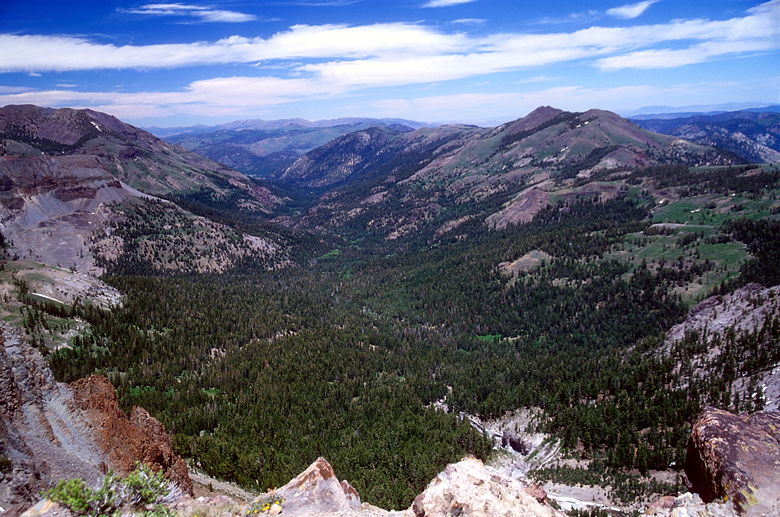
Valley view
While I sat and ate, I endured the constant buzzing of flies all around
me. Luckily they weren't the biting kind. I was a bit surprised I didn't
see anyone else on the summit, considering it was a holiday weekend. But
I guess the drive and the cross-country travel limits the number of people
who make it to the top. Although you wouldn't guess it by the size of the
summit register.
Another summit view
More summit views
I left the windy summit around 2pm. I retraced my steps, but not all of
my steps. In particular, when I descended from the big saddle, I veered
to the left to avoid the steep gully I'd ascended. This made life much
easier, and I soon encountered man-made paths through the bushes. Once
I was past the gully, I veered to the right to try to end up higher on
the established trail than where I left it. I was sure I wouldn't miss
the trail since I was going perpendicular to it.
The path I took downhill was speedy and safe. But as I descended, I thought
about whether there should be an actual trail to the top. It's not an easy
call to make. A trail would prevent hikers from randomly trampling
through the wildflowers. On the other hand, a trail would create a
permanent human presence. It depends on how many people climb to the top.
The more hikers, the better the argument in favor of a trail. Considering
that there's a summit register, as well as a permanent plaque on top, it
would seem that it's pretty popular. On the other hand, there doesn't
appear to be any appreciable damage to the wildflowers. So maybe it's
okay the way it is. The drive and terrain will deter enough people.
I don't know whether my description here will deter or encourage hikers.
I guess I'm ambivalent -- I neither want to deter nor encourage for this
particular hike. :)
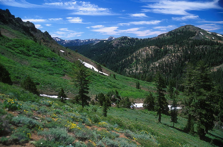
Eventually I heard a creek on my right. I descended roughly parallel to
it. I passed a campfire ring made of rocks, then shortly encountered
the trail. The creek I'd been following was the creek I'd crossed on the
trail so long ago. In case you are wondering, my altimeter now read
8430, and I reached the trail just a few feet from the creek.
I continued back along the trail, this time crossing a fallen tree to cross
the marshy area where I'd run into those two speed hikers. Before I reached
the climb back up to the Disaster Creek/Arnot Creek intersection, I sucked
my Camelbak dry. When I reached the top of the climb, I checked my
Gatorade supply. About 16 ounces left. I gulped down 8 ounces, then saved
the rest for later. I only had about 1.6 mostly flat miles to go.
As I sped through the Upper Gardner Meadow, I passed a pair of hikers. One
was setting up a tripod and reflector to take wildflower pictures. See,
there are some people out there more hard-core than I am when it comes to
photography. Although I do admit to wanting to get a reflector; I just
haven't gotten around to it yet.
Just before I started the climb back up to the first trail intersection,
I drank my last 8 ounces of Gatorade. Then I walked the remaining distance
to the parking lot, just as 5 or 6 other hikers and backpackers finished
their hikes. As soon as I got to my car I sucked down water and ate the
best apple I've ever tasted.
Return to Highland Lakes trip report.
| 

