| Hike | Miles | Vertical | Time | Rating |
|---|
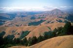
| Mt. Tamalpais State Park |
 | Mount Tamalpais
[Mount Tamalpais State Park] |
10.9 |
2700 |
4:50 |
8 |
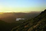
 | Cataract Falls
[Marin Municipal Water District] |
8.0 |
2105 |
5:18 |
7 |
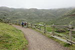
| A varied hike past several waterfalls, through redwood forests,
and on steep green hillsides with great views.
|
 | Matt Davis and Cataract Trails
[Mount Tamalpais State Park] |
6.3 |
990 |
3:15 |
7 |
| Moderate loop hike with some great views of San Francisco, the bay and the ocean.
|
 | Bootjack Loop
[Mount Tamalpais State Park] |
6.2 |
1080 |
2:20 |
7 |
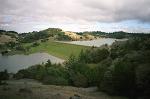 | Bon Tempe Lake
[Mount Tamalpais State Park] |
9.0 |
2000 |
4:45 |
6 |
| A misty walk down to the dam, and then a tough climb back
up.
|
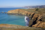
| Point Reyes National Sea Shore |
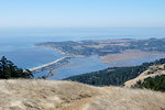
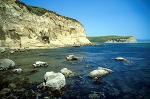
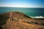
 | Drakes Head
[Point Reyes National Seashore] |
8.9 |
830 |
4:15 |
7 |
| Moderate hike to Drakes Head, overlooking Limantour Spit and the Pacific Ocean.
|
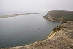
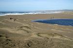
 | Estero Trail
[Point Reyes National Seashore] |
7.8 |
990 |
5:10 |
7 |
| Crabs, rays, egrets, turkey vultures, and sea lions
can be seen on this gentle hike to Sunset Beach.
|
 | Point Reyes Coast Trail
|
6.2 |
100 |
- |
7 |
 | Tomales Point
|
9.4 |
1330 |
5:28 |
7 |
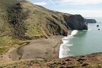
 | Alamere Falls - Not
|
9.0 |
1275 |
5:47 |
6 |
 | Abbotts Lagoon
[Point Reyes National Seashore
] |
3.0 |
200 |
3:50 |
6 |
| Hike to two lagoons great for bird watching, and a wind-swept
ocean beach.
|
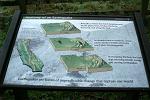 | Earthquake Trail
[Point Reyes National Seashore
] |
0.6 |
20 |
0:30 |
3 |
| Short walk along a paved path with some display signs about earthquakes,
and not much else.
|
 | Point Reyes 2007 Trip
[trip report] |
| A 3-day 2-night visit to Olema and Point Reyes with a couple short hikes
and elephant seal viewing.
|
| Other |
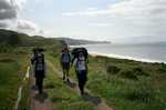
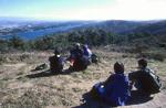
 | Angel Island Backpacking
[Angel Island] |
3.0 |
275 |
2:09 |
8 |
| A beautiful 2-day backpacking trip to a camp site with great views of San Francisco. |
 | Angel Island
[Angel Island] |
5.0 |
550 |
3:48 |
8 |
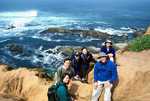
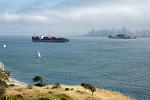
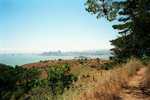
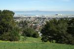
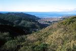
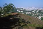
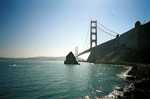 | San Francisco and Marin Headlands
[San Francisco] |
6.0 |
300 |
- |
8 |
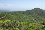
 | Mori Point and Sweeney Ridge
[Golden Gate National Recreation Area] |
8.2 |
1800 |
4:10 |
7 |
| Moderate loop hike (with some steep sections) visiting Mori Point (ocean views) and Sweeney Ridge (ocean and bay views).
|
 | Barnabe Peak
[Samuel P. Taylor State Park] |
6.0 |
1490 |
4:03 |
7 |
| A hike through the forest and wildflowers up to the top of
Samuel P. Taylor State Park near Point Reyes, where there are great views
of the surrounding area. |
 | Muir Woods
[Muir Woods National Monument] |
6.0 |
1115 |
3:29 |
7 |
| A hike among the redwoods at Muir Woods on a crowded
Labor Day weekend. |
 | Montara Mountain (San Pedro Valley County Park)
[San Pedro Valley County Park] |
7.1 |
1720 |
4:16 |
7 |
| Moderate hike to the top of an antenna-topped mountain with views of the ocean,
bay, and Pacifica.
|
 | Montara Mountain / McNee Ranch
[McNee Ranch State Park] |
7.6 |
1910 |
4:24 |
7 |
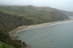
 | Tennessee Valley
[Golden Gate National Recreation Area] |
3.9 |
430 |
2:51 |
6 |
| A very crowded, mostly flat hike to a pretty beach in Marin county.
|
 | Hill 88
[Golden Gate National Recreation Area] |
5.4 |
1100 |
3:33 |
6 |
| A 5-mile loop hike with coastal views, past World War II era forts, and rolling green hills.
|
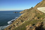 | Devil's Slide Trail
[San Mateo County
] |
2.4 |
320 |
1:00 |
6 |
| A short walk on a paved multi-use trail with great views of the Pacific Ocean.
|
 | Sweeney Ridge
[Golden Gate National Recreation Area] |
4.5 |
1025 |
2:48 |
6 |
 | Quail Trail Loop
[Junipero Serra County Park] |
1.5 |
230 |
1:42 |
5 |
| Very short hike near 280 with nice views of the bay overlooking SFO.
|
 | Brooks Falls
[San Pedro Valley Park] |
3.0 |
500 |
1:44 |
5 |
| A short semi-urban hike with faraway views of a trickling waterfall.
|
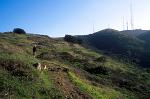 | San Bruno Mountain
[San Bruno Mountain State & County Park] |
3.1 |
850 |
2:08 |
5 |
| A hike mostly through low brush culminating in a peak topped with
radio towers and satellite dishes.
|
 | Mount Davidson
[Mount Davidson Park, San Francisco] |
0.5 |
150 |
0:30 |
5 |


