|
The parking lot was nearly full as we pulled into the lot around
noon. It was quite warm, as spring had arrived early, disguised as
summer. I had mountain biked in Arastadero Preserve a couple times
before, but in winter when it was muddy and brown. Instead, the trails
were now dry and the hills were green. While you should be on the
lookout for mountain bikers, they were surprisingly not much of a
problem. The trails are wide enough that hikers and cyclists can coexist.
The first 0.14 miles from the parking lot follows Arastadero Road.
After crossing the road (traffic does not stop, so be careful!),
the trail crosses a small foot bridge and then settles into a wide
dirt road. The first half mile from the parking lot is fairly
uninteresting.
After a half mile, we reached Arastadero Lake. You can fish in the lake,
and we saw 3 anglers on the far side of the lake. However, there's not
much usable shoreline here, and it's not the prettiest lake you'll see.
After pausing briefly at the lake, we contained straight on the Juan Bautista
de Anza Trail. As we steadily climbed the short hill, we were passed by
an equestrian, the only one we'd see on the trail. Now the views begin
to open up, with large oak trees and rolling green hills.
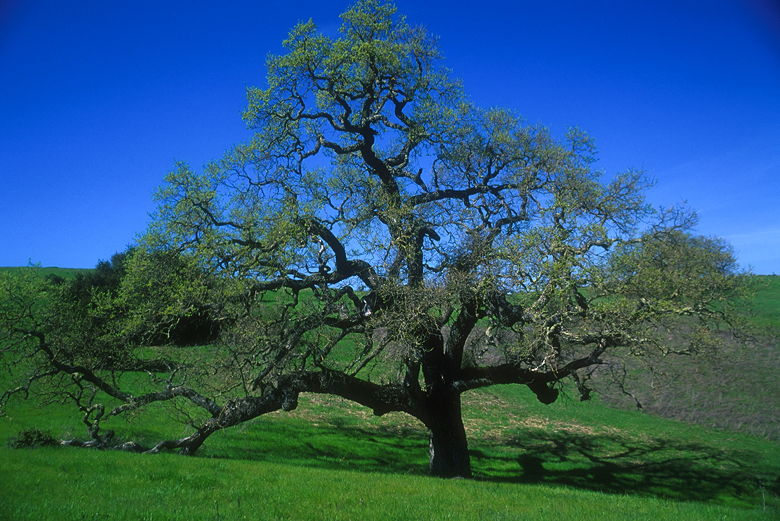
Oak tree
At the top of the hill, we passed the intersection for the Meadowlark
Trail and instead continued on the mail trail. Shortly, we could see
cyclists and cars on Arastadero Road in front of us. We turned left
onto the unsigned Ohlone Trail, left again onto the Meadowlark Trail,
and then quickly right to continue on the Meadlowlark Trail. If I had to do
it again, I probably would have made the left turn onto the Meadowlark
Trail from the Juan Bautista de Anza Trail. It would have avoided getting
close to Arastadero Road and the traffic noise.
We now followed the Meadlowlark Trail as it skirted the edge of the forest.
The sun beat down on us as we hoped the trail would lead into shade.
Unfortunately, it did not, staying just outside the edge of the forest at
every twist and turn. The hills were dotted here and there with poppies,
but there were no spectacular wildflower displays at this time. The trail
climbs gradually. Eventually we spotted a large eucalyptus tree at the top
of the hill. There we stopped for a break.
Under the ample shade of the eucalyptus tree, we enjoyed the view.
Directly below us, two blue birds flitted about on the skeleton of a
now leafless tree. Below that, the rolling green hills spread out to the
east. And beyond that, in the distance, is San Francisco Bay.
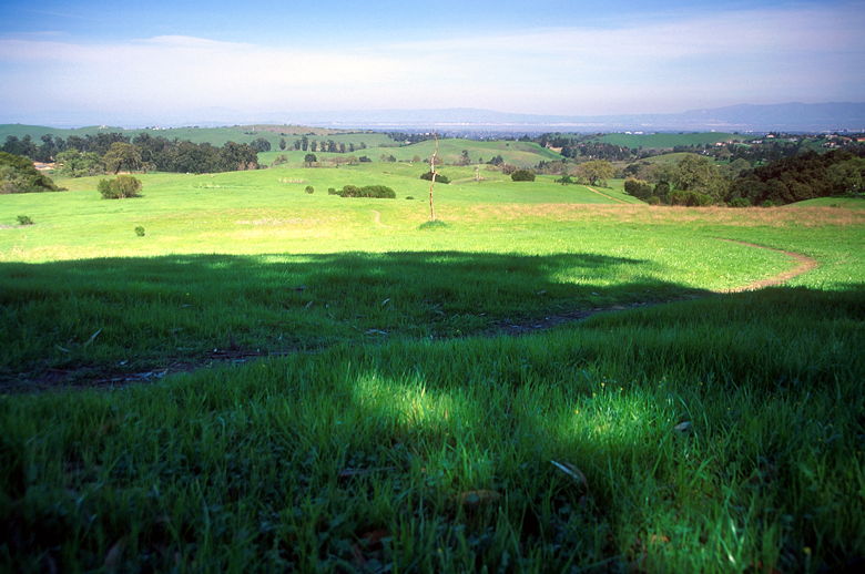
View from the hillside
While we enjoyed the shade, a couple of mountain bikers huffed and puffed
their way up the hill, the second one having to get off. We would later see
them heading down the hill via the Acorn Trail.
We continued on the Meadowlark Trail, then turned left onto the Woodrat
Trail. This singletrack trail has a series of gentle switchbacks which
leads down into blessed shade of forest. Unfortunately, this nice
section of trail is less than half a mile. At the bottom is the wide
Arastadero Creek Trail, which is really a gravel road. The road supposedly
parallels Arastadero Creek, but the creek wasn't much in evidence. We also
could not see Sobey Pond anywhere. I don't know if this was because it
was hidden from view, or just dried up.
We followed the trail all the way back to Arastadero Lake. There's really
nothing to see along this stretch of trail. If i had to do it again, I
would probably turn left onto the Acorn Trail and return that way. After
reaching the lake, we retraced our original steps, taking the Juan
Bautista de Anza Trail back to the road crossing, and then the trail back
to the parking lot.
| 

