|
Daryl, Jean, Kane, Lan and I snowshoed in the Echo Lakes area.
After leaving our cabin in South Lake Tahoe and driving to the
Sno-Park, we started to get ready. The weather was perfect, with
a bright blue sky inviting us to hike to our heart's content.
We saw kids playing in the snow, which lay in solid walls around
us, 10 feet high. We saw people with snowboards strapped to their
backs, prepared for a breathtaking backcountry descent.
I took out my trekking poles and put on the new basket attachments
I'd bought for them. I felt confident they wouldn't accidentally
detach this time. I was a bit disappointed not to be able to find
my balaclava, however. I searched and searched, but settled instead
on using a hat and neck warmer.
It wasn't until 10:45am that we finally hit the trail. A couple
was putting on their snowshoes at the trailhead. The trail was
very hard-packed at the beginning, however, so we decided to just
use our unaided hiking boots for the first part of the trail.
Less than a half mile into the hike, Lan and I put our snowshoes
on. Then before reaching the lake, Daryl and Kane put theirs on.
Jean had been planning to go snowboarding, but had decided to
join us on our hike instead. She didn't have snowshoes, which
meant she just did her best with her hiking boots. Along this
first part of the trail, it wasn't much of a problem.
Her first big obstacle came as we made a short descent to Lower
Echo Lake. The snow was soft and deep, and she sank up to her
knees in places. Snow engulfed small buildings and the restrooms.
But when we reached the edge of the lake, the trail became somewhat
packed.
Well, it wasn't so much a trail as it was...well, a lake. A frozen
lake with an unknown quantity of snow on top of it. Based on the
surrounding area, however, it's safe to say the snow was several
feet thick. Other snowshoers and cross-country skiers had made
various tracks in it.
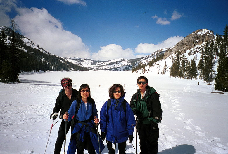
Daryl, Lan, Jean, and Kane before we start trekking across Lower
Echo Lake. That's Flagpole Peak on the right.
The scenery was beautiful, of course. The lake was set in a valley
with steep granite walls to the right, snow slopes on the left.
A bright blue sky above. The only problem was a wind which whipped
in our faces. At this point I regretted not finding my balaclava.
While my hat, neck warmer, and jacket hood protected most of my
head, the balaclava would have protected my cheeks and ears. Still,
it was sunny and not too bad. I wore just three layers on top
and two bottom layers the whole hike, though I had an extra fleece
top in my pack just in case the weather took a turn for the worse.
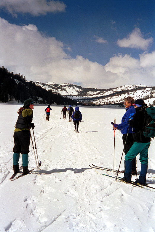
We encountered several groups of cross-country skiers on both
of the lakes.
Halfway across the lake, Jean told us to go on ahead, since she
couldn't keep up with just her hiking boots. She would just hike
to the end of the second lake and turn around. The rest of us
reached the edge of the lake and took a brief food break. Then
it was through the trees. A few feet later we were hiking on an
edge, just about 5 feet above liquid water. This gave me pause
for thought, as I'm sure it was icy cold and the thought of falling
into it made me glad I had my trekking poles for balance.
Upper Echo Lake is much smaller than Lower Echo Lake -- less than
half the size. We crossed it quickly. Lan's achilles' tendon was
acting up, so she decided she would turn around shortly after
that, as well. So Daryl, Kane, and I continued on toward the peak.
By the time we had reached the edge of the second lake it was
12:30pm. According to the book I was using, it was only about
1.5 miles to the peak; I foolishly estimated another hour to the
top. But with about 1400 feet of climbing in snow ahead of us,
that was being overly optimistic.
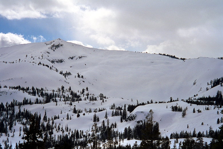
As we climbed, we saw a big mogul-covered slope to the left. We
hiked northwest, and then northeast through the forest, snow covering
all but a few large rocks. I think I saw brief glimpses of Echo
Peak through the trees, but we never got a clear view of it. In
that sense, it was one of the most frustrating hikes I've done
-- we could never tell exactly how far away we were from the end.
Anybody got a snowboard?
Halfway into the climb, Daryl decided to turn around. That left
Kane and me, following a cross-country skier's tracks up the mountain.
Kane was making good progress. He seemed strong the whole time,
so I let him do the hard work of leading, digging out steps in
the mostly unbroken snow. One thing I have to say is that hiking
in the wild, so to speak, is much different than hiking on a groomed
trail. At Royal Gorge, the trails are hard-packed and it's like
normal hiking. But hiking in deep, soft snow takes a lot more
energy. So much so that I didn't really care that I was letting
Kane do all the work -- I was keeping up, but I was too tired
to try to take the lead.
As time quickly went by, I started to grow nervous about the time.
We hadn't seen anyone else in over 30 minutes, and we had no idea
how much further the peak was. Certainly, no one was coming down
from the peak to let us know. At 1:30pm, I had to make a decision.
We stopped and looked at the book. My altimeter read 8450 feet,
about 450 vertical feet from the summit. I figured we might reach
the peak at 2:15pm, get back to the edge of the second lake at
3:00pm, and get back to the car at 4:30 - 5:00pm. Unfortunately,
I'd told Jean I'd be back down at 3-3:30pm, and we were planning
to meet some friends at Sierra-at-Tahoe around 4pm. I told Kane
to go on ahead while I tried to reach Jean on the radio. No luck
-- out of range. Kane said over the radio that he'd reached a
ridge and could see the other side of the valley now. I went up
a short ways to the place he'd been. Yes, I could see the other
side, but I still couldn't see any sign of the peak. After going
back and forth in my mind several times, I made the decision to
turn around, a part of me still kicking and screaming to keep
going up. Kane said his turn-around time was 2:30pm. After taking
a break for food, I turned around at 1:40pm.
I made quick time down the mountain, stepping and sliding in the
snow. A couple times I fell as the snow slipped out from under
me and I ended up on my back. After doing that one too many times,
I decided to proceed a little more cautiously, especially near
the exposed water.
At 2:00pm, Kane radioed down that he'd summited. The view was
gorgeous. I imagine it must have been similar to the one from
atop Mt.Tallac, though almost 1000 feet lower. To be honest, when
I heard how soon he'd summited, I felt like crap. I congratulated
him and continued on my descent. The entire rest of the trip I
was kicking myself for turning around. This was the first time
I'd ever failed to reach a peak on a hike. And it wasn't for any
other reason than I thought I needed to get down by a certain
time. Sunlight was not a factor, as the sun wouldn't set until
6pm and I certainly wouldn't have taken that long.
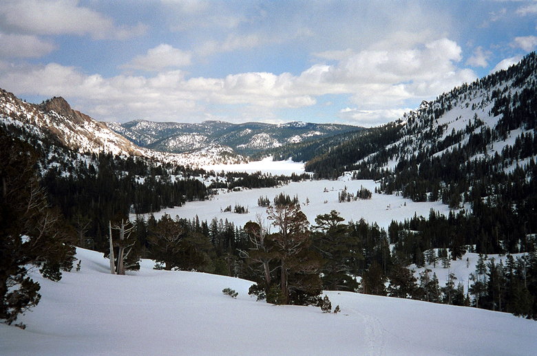
Upper Echo Lake (foreground) and the much larger (think perspective)
Lower Echo Lake (background)
I continued my miserable existence, hiking fast across the smaller
lake. I was determined not to let Kane catch up to me. As miserable
as I was, I would have felt even worse if he'd overtaken me, simply
because that would have completely negated my reason for turning
around -- to get down sooner. After pushing myself hard across
the lake, I stopped for more food and drink. Then it was the long
hike across the big lake.
As frustrating as it was not to be able to see the peak the whole
hike, the lake was frustrating for completely the opposite reason.
The whole time as you hike across the lake, you can see the buildings
on the other side. But every time you look up, they don't seem
to be getting any closer! Being a lake, it is of course completely
flat, and the lack of perspective forces you to just keep your
head down and take one step at a time to avoid getting flustered.
I finally made it to the other side. Kane radioed that he was
in the middle of the lake. I looked back but didn't see him. Which
lake had he meant? I later found out that he'd thought he was
on the last lake, but was frustrated when he reached the end only
to find the last lake in front of him -- he'd been in the middle
of the smaller lake! After taking another food break, I trudged
up the steep snow to the main trail leading back to the parking
area.
Shortly after getting onto this trail I ran into Daryl and Lan,
who were themselves still heading back. Daryl was just taking
off his snowshoes, since he didn't think he'd need them on the
packed surface. We hiked together for a short time as we went
by views of Lake Tahoe on our left. Lan made the mistake of asking
me why I'd turned back, which only further frustrated me. I ran
off ahead of the two of them so they could avoid my miserable
company.
I got back to the parking area at 3:30pm, which meant I'd gone
pretty damn fast. Jean and I went to Sierra, but never did find
our friends, who it turned out had left just before we got there.
I found out later than Kane finished the hike at 4:20pm.
I felt bad the whole drive back to the Bay Area. But now that
I've had a few days to think about it, it's okay. I'll take it
as a learning experience. I made a lot of mistakes. First, I hadn't
looked carefully into permits and parking before the hike. I hadn't
planned a starting time; I should have started before 10:45am.
To be honest, I hadn't even been sure we would have tried for
the peak, since the book warned of avalanche danger. But there
wasn't any real danger on the parts of the trail we were on. I
made the mistake of estimating 5 hours for the hike, not taking
into account the snow conditions. And I made the mistake of planning
something right after the hike, not giving me any breathing room
in case the hike took longer than expected. And I still haven't
found my balaclava.
In a sense it was one of my most depressing hikes. But it was
beautiful, the views were nice, and it's something I might return
to in the future. Especially now that I know everything that's
involved in finishing the hike.
Credits: Kane - 9.3 miles, 1500 feet; Kevin - 8.5 miles, 1100
feet; Daryl - 7.5 miles, 600 feet; Jean and Lan - 6 miles, 200
feet
| 

