|
Jean, Jennie and I hiked to the top of Monument Peak, aka Transmission
Tower Central. Jean and I accidentally took the wrong Calaveras
Road exit. It was a gorgeous side trip, passing by Sunol Regional
Park and Calaveras Reservoir. The hills were glowing green and
the trees were beautiful. Unfortunately our detour made us over
an hour late to our actual destination. (If you're going, make
sure you take the 237/Calaveras Road exit, not the 84/Calaveras
Road exit)
We started off around noon from Sandy Wool Lake. There were families
picnicking, golfers golfing, people fishing in the lake, and hang gliders
and paragliders coming in for a landing. We were some of the few
people actually hiking on this wonderfully sunny and warm day.
We headed steeply up the Tularcitos Trail before going through
a cattle gate and continuing up the Agua Caliente Trail. Along
the way we could see paragliders flying overhead, mimicking the
birds. The trail for the most part is a fire trail, but it's closed
to bike traffic. We came to an intersection with a service road
leading up to the clearly visible 960 foot launching area for
hang gliders and paragliders. As we winded our way up the trail,
cows moved out of our way, giving us curious glances.

Moo!
We crossed the second of 10 cattle gates. In places, the trail
was uneven, hardened mud, made that way by cows and horses, making
it hard to walk on. In other places, grasses and flowers sprouted.
On either side of the trail were rolling green hills dotted with
minimal tree cover except where small streams flowed. Wildflowers
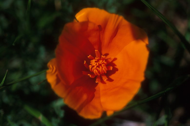
were small in number. A patch of poppies here and there, and that's
about it.
We reached a trail intersection and took the fork off to the right
-- the Monument Peak trail. As we climbed we got better and better
views of the rolling hills, the houses of the Fremont hills, the
San Francisco Bay salt ponds, and much of the south Bay Area.
But while it had started out a warm and sunny day, the clouds
had started to move in and the wind picked up. We stopped for
lunch with a view under slightly graying skies.

California Poppy

A closer look
After lunch we began a steep ascent -- whoever graded this section
of the trail wasn't in a good mood that day. Eventually, as we
neared the top, we passed a huge electronic transmission tower
with dozens of antennas and 9 high tension cables spread out in
three different directions to keep it all anchored to earth. Satellite
dishes and other towers and buildings stood on hills close by.

Huge antenna near the top

The hills to the north
We reached another trail intersection. A trail leads north toward
more hills and eventually Mission Peak. A mountain biker came
toward us from that direction. We turned right up a service road
to complete our journey to the top of Monument Peak, elevation
2594. The top is a broad flat area with the base concrete remains
of an old antenna tower. In addition to the previous views westward,
we could also now see rows of rolling green hills and scattered
lakes to the east.

View from the top

Group summit shot

Close-up of the rocks

Another rock
For our return trip, we decided to take the Agua Caliente Trail
instead of the Monument Peak Trail. This section of the trail
is open to mountain bikers, but we figured it was relatively late
in the day so we wouldn't have to worry about them much. What
we did have to worry about were cows. As descended rapidly (at
up to 50 vertical feet per minute!) the cows started looking at
us. What was strange was that they were ALL looking at us. About
15 of them. Eventually, as we got closer they turned and disappeared
over a hill. But then we turned a corner and there they were,
standing just off the trail to the left. And they were being joined
by more of their friends. And even more...until we were facing
at least 50 cows. We slowly continued on the trail and the few
cows who were on the trail got out of our way. Except one. This
was the biggest, baddest cow in town, and it wasn't going to move
an inch. It turned sideways so it completely blocked the trail.
Jean wanted to show it who was the top of the food chain, but
I suggested we simply walk around, which we did.

The cows which blocked our way
The trail seemed longer on the way back, but we eventually intersected
a road which we'd crossed earlier. Unfortunately, we'd intersected
it at a point about 100 vertical feet higher. At this point we
didn't feel like expending the extra energy, so we took the road
back instead. The service road took us past a few private residences
and the Minnis Ranch Training Center. We were walking on the road
used by hang gliders to haul up their gear.
From the training center it's a short hike down to the parking
lot next to Sandy Wool Lake. The sun was just setting as we wrapped
up and drove back into town, Jean and I suddenly finding out how
close the park is to civilization.
| 


