|
This was the first hike I did with baby Nathan on my back. Apparently
some babies hate being stuck in a pack, but Nathan took to it readily.
Now nearly 8 months old, he spent much of the first half of the hike
looking out the right side (throwing off my center of gravity, of course),
looking at the forest. But I'm getting ahead of myself...
When you park at Skeggs Point, you'll undoubtedly see lots of mountain
bikers getting ready to hit the trails. After getting ready ourselves,
we walked down the hill (making a right out of the parking lot), then
shortly (after about 50 yards) walked across the street to the trailhead.
There's a sign here with a stack of maps.
We started off on the Tafoni Trail. The trail goes up and down, up and
down, but not really steep or very far up or down. The trail is a wide
dirt road, almost completely shaded, with redwoods and fir trees to the
towering above. Nothing really stands out here, but it's a pleasant
enough stroll through a forest. Also, there were plenty of purple irises
along the trail.
After a mile, we reached a trail intersection with the Fir Trail. We
continued along the Tafoni Trail here, then shortly turned right onto
the hiker-only trail down to the sandstone formations. Here, I was a bit
taken aback to find out that the area is under restoration. I had been
here in 1999 and it was open for hikers. But now a fence and signs
prevent hikers from walking through the area. Instead, the trail
dead-ends at a observation deck where you can view some of the remaining
formations close-up. It didn't seem quite as impressive as when I had
visited 5 years ago.
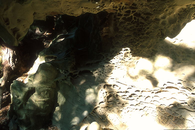
Sandstone formations
After a short break at the observation deck, Nathan encouraged us to
start our return trip, during which he slept most of the way. After
heading back up the trail and retracing our steps on the Tafoni Trail
to the intersection, we took the right fork onto the Fir Trail. This
trail is flatter and a bit shorter than the Tafoni Trail. The
scenery is similar to the Tafoni Trail, but with a few unshaded patches and
fewer redwood trees. There was also a chilly wind coming through in the
late afternoon. Remember that you are over 2000 feet above sea level, so
it is generally a few degrees cooler up here.
The last few yards of the trail are paved, and soon enough we were back
at the trailhead, crossing Skyline and back at Skeggs Point. All in all,
a somewhat anti-climatic hike considering my previous experience at
the sandstone formations, but a pleasant enough hike through the forest.
|


